Lima
Lima is the capital and the main city of the Republic of Peru. is located on the central coast of the country, on the edge of the Pacific Ocean, forming a large and populated urban area known as Lima Metropolitana from 70 km north to south, from the district of Ancón to the district of Pucusana and 44 km east to west, from the district of La Punta to Chosica (district of Lurigancho Chosica), flanked by the coastal desert and extended over the valleys of the rivers Rio Chillón, Rimac and Río Lurín. According to official data from the INEI in 2020, the city of Lima has more than 9.5 million inhabitants, while Lima Metropolitana borders 11 million people (32% of the Peruvian population), numbers that make it the most populated city in the country.
| Lima City of Kings | ||||
|---|---|---|---|---|
| Capital of Peru | ||||
| From top to bottom and from left to right: A circuit of beaches of the Costa Verde from the Armendariz Gorge, Plaza Mayor of Lima, Catedral de la Reserva, Centro Financial in San Isidro, Basilica and Convent of San Francisco and Ciudad de Lima. | ||||
| ||||
| Other names: City of Kings. The Three Times Crowned Villa. The Pearl of the Pacific. Garden City. | ||||
| Slogan: Hoc signum vere regum est (in Latin: "This is the real sign of the Kings") | ||||
| Himno: Lima Hymn | ||||
| Lima Location of Lima in Peru | ||||
| Lima Location of Lima in South America | ||||
| Interactive Map | ||||
| Coordinates | 12°03′00″S 77°02′00″W / -12.05, -77.03333333333333 Coordinates: 12°03′00″S 77°02′00″W / -12.05, -77.03333333333333 | |||
| Official language | Spanish | |||
| Entity | Capital of Peru | |||
| ・ Country | | |||
| ・ Province | | |||
| Mayor of Metropolitano | Jorge Muñoz Wells | |||
| Subdivisions | 43 Districts | |||
| Historical Events | ||||
| ・ Foundation | January 18, 1535 (485 years old) | |||
| Surface | ||||
| ・ Total | 2,672.28 km² | |||
| Altitude | ||||
| ・ Average | 161 m s n. m. | |||
| Climate | BWh Subtropical Arid | |||
| Population (2020) | Position 1St | |||
| ・ Total | 9,674,755 . | |||
| ・ Density | 3,697 room/km² | |||
| Gentilicio | Lima, -a | |||
| GDP (nominal) | Position 1St | |||
| ・ Total (2017) | | |||
| ・ GDP per capita | | |||
| IDH | 0.7221 - Alto | |||
| Time zone | UTC-5 | |||
| Postal Code | 15,001, | |||
| Phone Prefix | 01 | |||
| ISO 3166-2 | PE-LMA | |||
| Patron(a) | Saint Rose of Lima | |||
| Official website | ||||
| Member of: Iberoamerican Capital Union Mercocities | ||||
On January 18, 1535, the city was founded under the name of the City of Kings by the Spanish conquistador Francisco Pizarro within the agricultural region known by the indigenous people as Lima, a name he acquired over time. It was the capital of the Viceroyalty of Peru for its valleys and low sea level to replace Jauja that was on the heights of the Andes, the viceroyalty at the time, it functioned as the most relevant administrative entity of the Hispanic monarchy within South America, while Lima was in turn the largest and most important city in South America during the entire colonial period. After that, the independence process became the capital of the Free Departments and later of the Peruvian Republic, was also the capital of the Nor-Peruvian State and was initially the capital of the Peruvian-Bolivian Confederation.
Lima is home to one of the oldest higher education institutions in the New World. The National University of San Marcos, founded on May 12, 1551, during the Spanish viral regime, is the oldest university in continuous operation in the Americas.
Metropolitan Lima is divided into 50 districts in total, where the province of Lima has 43 districts and the constitutional province of Callao has 7 districts, both provinces have had regional autonomy since 2002. It is also organized in cones or axes of the city: Cono Norte, Cono Sur, Cono Este, Cercado and el Callao.
It is now considered the political, economic, industrial, cultural, financial and commercial center of the country. Internationally, it is currently the fifth largest city in Latin America, by GDP and fifth by population, the largest city in the South American Pacific, the third most populous metropolitan area in Hispanoamerica, and the city occupies fourth place within the most populous cities in South America and is one of the thirty most populated urban agglomerations in the world. Due to its geostrategic importance, it has been defined as a global "beta+ class" city.
In October 2013, Lima was chosen to host the 2019 Pan American Games. It also hosted the December 2014 United Nations Climate Change Conference, which was hosted in 2008 and 2016 by the APEC World Forum, the Miss Universe 1982 contest, and is scheduled to host the event 2021 U-17 Football World Cup.
Toponymy
The current Rimaq River Valley was named after Rimaq (pronounced [・li.maq] according to the pronunciation of the lambdacism of the coastal Quechua and as [i.maq] in the variants of the Sierra) as a reference to the construction now known as Santa Ana's huaca ("Indians guaca de Lima that departs zyan ychmas, it was a round stone". As in other toponyms, the final occlusive ended up being eliminated by passing into the spanish language, with the spelling after coexisting in documents with the formsLimacand Lyma.
At the origin of this toponym, as with many others in the New World, it is very likely that Spaniards would easily accept what the aboriginal communities already used, mutating it to a very similar sonority extracted from the Iberian geography. In this case they could apply the one of the Limia River, transboundary between Portugal and Spain, whose Portuguese name is River Lima.
Founded on January 18, it was named Ciudad de los Reyes because of the proximity of the date to January 6, the Day of the Three Kings and perhaps also as a tribute to the Kings of Spain: Juana I and Carlos I, however, the toponymic name of the region was always maintained, which gradually became consolidated on the founding name, which is why the new center of town became known as the city of Lima. The river's name, on the other hand, saw its spelling altered according to the uses of the Third Limense Council influenced by the habits of Aymara pronunciation, as with many other toponyms of Quechua origin.
Symbols
- Flag
Historically, it's known as "Estandarte de la Ciudad de los Reyes del Perú" (State of the City of the Kings of Peru). it's made up of a silk canvas painted in gualda, and in the center is the coat of arms of the embroidered city.
- Shield
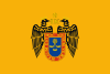
The coat of arms of Lima was granted by the Spanish Crown on December 7, 1537 by Real Cédula signed in Valladolid by Emperor Carlos V and his mother Queen Joan I of Castilla, endowing the city with the shield. It is composed of a main Azur field, with three golden crowns of kings placed in triangle and above them a star And the three crowns are touching gold, and the gold letters of gold, which say, Hoc signum vere regum est (This is the real sign of the kings). exterior to the shield are the initials I and K (Ioanaand Karolus), which are the names of Queen Juana I and her son Carlos I. On the letters is a star and hugging two faced eagles of crowned sword, which are fastened or the shield.
- Himno
The Lima anthem was first heard on January 18, 2008, in a solemn session attended by then Peruvian President Alan García, the mayor of the city Luis Castañeda Lossio and various authorities. The councilors Luis Enrique Tord (author of the lyrics), Euding Maeshiro (composer of the melody) and the music producer Ricardo Núñez (arranger) were responsible for the creation of the anthem.
History
Pre-Hispanic times

Although the history of the city of Lima began with its Spanish founding in 1535, the territory formed by the valleys of the rivers Rimac, Chillón and Lurín was occupied by pre-Inca settlements, which were grouped under the mistress of Ichma. Maranga culture and Lima culture were the ones that established and forged an identity in these territories. the sanctuaries of the Lenient (current Puruchuco) and Pachacámac (the main pilgrimage sanctuary during the Inca era) were built.
These cultures were conquered by the Wari Empire during the heyday of its imperial expansion. It is during this time that the ceremonial center of Cajamarquilla was built. With the decline of Wari importance, local cultures have regained autonomy, highlighting the Chancay culture. Later, in the fifteenth century, these territories were incorporated into the Incan empire. This time we can find a great variety of huacas across the city, some of which are under investigation.
The most important or well-known ones are Huallamarca, Pucllana and Mateo Salado, all located in the middle of Lima districts with very high urban growth, so they are surrounded by business and residential buildings; however, this does not hinder their perfect conservation status. On the outskirts of the city are the ruins of Pachacámac, an important religious center built by the Lima culture 3000 years ago that was used even until the time when the Spanish conquerors arrived.
Virreinal period
In 1532, the Spaniards and their indigenous allies (of the ethnicities under the Incas) under Francisco Pizarro took Atahualpa prisoner in the city of Cajamarca. Although a ransom was paid, he was sentenced to death for political and strategic reasons. After some battles, the Spaniards conquered their empire. The Spanish crown named Francisco Pizarro governor of the lands he had conquered. Pizarro decided to found the capital in the Rimac valley, after the failed attempt to constitute it in Jauja.
He considered that Lima was strategically located, close to a favorable coast for the construction of a port but cautiously away from it to prevent attacks on fertile lands by pirates and foreign powers, and with a convenient fresh climate. On 18 January 1535, Lima was founded under the name of Ciudad de los Reyes, named in this way in honor of the epiphany, on territories that had been of the curaca Taulichusco. the explanation of this name is because "on the same dates in January the Spanish were searching for the place for the founding of the site of the new city, [. ... not far from the sanctuary of Pachacámac, near the Rimac River.
However, just like the region, originally called Nueva Castilla and then Peru, the Ciudad de los Reyes soon lost its name in favor of Lima." Pizarro, with the collaboration of Nicolás de Ribera, Diego de Agüero and Francisco Quintero, personally mapped the Plaza de Armas and the rest of the city's grid, building the Virreinal Palace (now transformed into the Palacio de Armas) In August 1536, the flourishing city was besieged by the troops of Manco Cápac II, but the Spanish and their indigenous allies managed to defeat them. In the following years, Lima gained prestige by being appointed capital of the Viceroyalty of Peru and seat of a Royal Audience in 1543.
Over the next century, it flourished as the center of a vast commercial network that integrated the viceroyalty with America, Europe, and East Asia. But the city was not without dangers. violent earthquakes destroyed much of it between 1586 and 1687, which will generate a great display of constructive activity. It is then that aqueducts, tajamares and walls of containment appear before the flood of rivers, the bridge over the Rimac ends, the Cathedral (finished in 1622) is built and numerous hospitals, convents and monasteries are built. Then we can see that the city is organized around its neighborhoods. Another threat was the presence of pirates and pirates in the Pacific Ocean, which motivated the construction of Lima's walls between 1684 and 1687.
The 1687 earthquake marked a turning point in Lima's history, as it coincided with a recession in trade for economic competition with other cities like Buenos Aires. With the creation of the Viceroyalty of New Granada in 1717, the political boundaries were reorganized, and Lima lost only some territories that actually enjoyed their autonomy. a strong earthquake severely damaged the city and destroyed Callao, forcing a massive reconstruction effort by viceroy José Antonio Manso de Velasco.
In the second half of the eighteenth century, the ideas of enlightenment about public health and social control influenced the development of the city. During this period, the Peruvian capital was affected by the reforms of the Borbonic region as it lost its monopoly on foreign trade and its control over the important mining region of Upper Peru. This economic weakening led the city's elite to depend on the positions given by the virreinal government and The Church, which helped to keep them more connected to the Crown than to the cause of independence.
The biggest political-economic impact that the city experienced at the time came with the creation of the Viceroyalty of the Río de la Plata in 1776, which changed the direction and directions imposed by the new commercial traffic. A combined expedition of Argentine and Chilean independentists led by General Don José de San Martín landed in southern Lima in 1820, but did not attack the city ... Faced with a naval blockade and guerrilla action on land, viceroy José de la Serna was forced to evacuate the city in July 1821 to save the realist army. fearing a popular uprising and lacking the means to impose order, the City Council invited Saint Martin to enter the city, signing a Declaration of Independence at his request. the war was not over and in the next two years the city changed hands many times, suffering abuse from both sides.
Republican era

Proclaimed the independence of Peru in 1821 by General San Martín, Lima became the capital of the new Republic of Peru. It was the seat of the government of the liberator and also the seat of the first Constituent Congress in the country. The first years of Peruvian republican history were characterized by the constant confrontation between military warlords, who were aiming to govern the country and for which they were trying to take over the seat of government.
Thus, Lima suffered several sieges and armed clashes in its streets. From an urban perspective, the constant growth that the city experienced gave rise to a phenomenon of modernization. In 1862, the process of changing the urban nomenclature of the city began, and in 1868, at the request of President José Balta, the demolition of the surrounding walls was arranged, giving way to the first major avenues.
Because of the Pacific War, from 1881 to 1883, Lima was occupied by Chilean forces; after the withdrawal of the Chilean army, a reconstruction process was initiated, it was limited due to the clashes between Andrés Avelino Cáceres and Nicolás de Piérola. In the late nineteenth century, with Piérola assuming power and the beginning of what was called the Aristocratic Republic, began its true and intense reconstruction that lasted until the remodels that Augusto Leguía carried out in preparation for the centenary of independence in 1921. At the beginning of the twentieth century, the construction of avenues that served as a matrix for the development of the The avenues Paseo de la República, Leguía (now called Arequipa), Brasil and the landscape Salaverry that were heading south and the avenues Venezuela and Colonial to the west were stretched, joining the port of Callao.
In the 1930s, major construction began with the renovation of the Government Palace and the Municipal House. These buildings peaked in the 1950s, during the government of Manuel A. Oria, when the large buildings of the Ministry of Economy and the Ministry of Education (Javier Alzamora Valdez building now the seat of Lima's High Court of Justice), the Ministry of Health, the Ministry of Labor and the Hospitals of Workers and Employees Insurance, as well as the National Stadium and several large housing units were built
Also in those years, a phenomenon that changed the configuration of the city began, which was the massive immigration of inhabitants of the interior of the country, producing the exponential growth of the capital population and the consequent urban expansion. The new populations were settled on land near the center, which were used as an agricultural area. The current districts of Lince, La Victoria, were populated to the south; Breña and Pueblo Libre to the West; El Agustino, Ate and San Juan de Lurigancho to the east and San Martín de Porres y Comas to the north.
As an emblematic point of this expansion, the self-governing community of Villa El Salvador (now a district of Villa El Salvador) was created in 1973 and is located 30 km south of the city center and now integrated into the metropolitan area. In the 1980s, terrorist violence added to the disorderly growth of the city the increase in the number of people arriving as internally displaced. The historic center The city suffered increasing deterioration and many parts of the city were constantly deprived of basic services.
Geography
Location
Lima is located in the coastal desert of Peru, at the foot of the western slope of the central Andes of Peru. Although it was initially founded on the Rimac River Valley, today it extends over extensive desert areas and even over other valleys.
It borders the coast from the km 50 of the North American, at the border of the district of Ancón with the province of Huaral; up to km 70 of the Panamericana Sur, at the edge of the district of Pucusana with the province of Cañete; which add a little more than 80 miles of coastline and beach. To the east, it extends approximately to km 37 of the Central road, at the edge of the district of Lurigancho-Chosica with the province of Huarochiri.
Climate
The climate of the city is particularly important given its location. It combines an almost total absence of precipitation, with a very high level of atmospheric humidity and persistent cloud cover. Thus, it is surprising for its strange characteristics despite being located in a tropical area at 12 degrees south latitude and almost at sea level. The central Peruvian coast shows a series of atypical microclimates due to the influential and cold current of Humboldt that derives from Antarctica, the proximity of the Andes mountain range and its geographical location, giving Lima a subtropical climate fresh, desert and humid at the same time.
It can be said that it has a warm climate without excessive tropical heat or extreme colds that require heating at home, except for very few winters. The average annual temperature is 17.5 to 19 °C, with a maximum annual summer temperature of about 29 °C. Summers, from December to April, have temperatures ranging from 29 to 30 °C during the day to 21 to 22 °C at night. Only when the Child Phenomenon occurs can the temperature in the summer season exceed 31 °C. Winters range from June to mid-September, with temperatures ranging from 19 to 12 °C, with 8.8 °C being the lowest temperature historically recorded. The months of spring and autumn (September, October and May), they have temperate temperatures ranging from 23 to 17 °C.
On the other hand, relative humidity is extremely high (up to 100%), producing persistent haze from June to December until the early summer when clouds are lower. It is sunny, humid and hot in summers (December-April), cloudy and temperate in winters (June-September). The rain is almost nil. The annual average is 7 mm reported at Jorge Chávez International Airport, being the smallest number in a metropolitan area in the world.[quote required] A rain in Lima can be seen as a strange phenomenon for most of the population.
It has only rarely rained heavily in the city. The phenomenon of rain occurs especially in the districts near hills such as La Molina and Lurigancho-Chosica. One of the strongest rains in the city in the last decade, was endured by the districts of La Molina, San Juan de Miraflores, Villa María del Triunfo, Villa El Salvador and Cieneguilla on April 6, 2001. rain with thunder and lightning, which surprised the inhabitants. It was produced by the detachment of a convective cell that traveled from the Sierra to the coast. The last thunder rain occurred on March 7, 2009 at La Molina and Ate Vitarte, the result of the arrival of clouds from the Sierra.
When it rains very hard in Lima, there are usually problems, as the city is not prepared for the rain. In the hills, there are peaks or avalanches. When a dry break reactivates with rain, it causes great damage. In 2002 there were landslides in the Huaycan and Santa María area of Huachipa. There have also been some huaycos in Lurigancho-Chosica and Chaclacayo over the years. The last abnormal phenomenon in Lima of consideration occurred in January 2011, due to the arrival of clouds from the highlands to the coast, which produced intense rains in several capital districts. Lima has only 1284 hours of sunshine per year, 28.6 hours in July and 179.1 hours in January, exceptionally low values for latitude. From January to April clear skies predominate; in May, and from October to December, the skies remain partially cloudy; from june to september, the skies remain dull, almost permanently covered. The combination of climatic phenomena is presented as follows:
Humboldt's cold current that runs along the coast cooles the water temperature. This is much colder than the tropical latitude the city is located in. Thus, cold conditions at sea level with a higher atmosphere warmer by solar action, generate a thermal investment that prevents the phenomenon of convection, whereby the warmer and less dense air rises. This, coupled with the surrounding Andean mountain range, makes an almost permanent layer of extremely low thick cloudiness (less than 500 meters from the ground) present, which prevents direct solar radiation from passing through. In turn, blocking by a layer of hot air above prevents the formation of cumulonimbus vertical development clouds, which explains the absence of precipitation. This is the reason for the paradox of having an extremely cloudy and humid, yet desert, climate. The low rainfall (less than 8 mm per year) known as a tow is the result of the condensation of the low clouds that form the system.
| Month | Jan. | Feb. | Sea. | Apr. | May. | Jun. | July. | Aug. | Sep. | Oct. | Nov. | Dec. | Annual |
|---|---|---|---|---|---|---|---|---|---|---|---|---|---|
| Temp. max. Aps. (°C) | 31 | 35 | 32 | 31 | 30 | 28 | 30 | 26 | 26 | 26 | 27 | 31 | 32 |
| Temp. max. mean (°C) | 26 | 26 | 26 | 24 | 22 | 20 | 19 | 18 | 19 | 20 | 22 | 24 | 22 |
| Temp. mean (°C) | 23 | 23 | 23 | 21 | 20 | 18 | 17 | 17 | 17 | 18 | 20 | 21 | 20 |
| Temp. min. mean (°C) | 20 | 20 | 20 | 18 | 17 | 16 | 15 | 15 | 15 | 16 | 17 | 18 | 17 |
| Temp. min. Aps. (°C) | 16 | 17 | 16 | 13 | 12 | 11 | 8 | 9 | 10 | 10 | 8 | 10 | 8 |
| Rains (mm) | 3 | 3 | 0 | 0 | 3 | 2 | 3 | 3 | 3 | 2 | 2 | 0 | 16 |
| Rainy days (≥ 1 mm) | 4 | 2 | 3 | 2 | 5 | 11 | 12 | 15 | 13 | 7 | 5 | 3 | 82 |
| Sun Hours | 179.1 | 169 | 139.2 | 184 | 116.4 | 50.6 | 28.6 | 32.3 | 37.3 | 65.3 | 89 | 139.2 | 1,284 |
| Relative humidity (%) | 85 | 80 | 80 | 85 | 85 | 85 | 85 | 85 | 85 | 85 | 85 | 85 | 84.2 |
| Source No. 1: Weatherbase . (Temperature, precipitation and relative humidity). | |||||||||||||
| Source No. 2: Universidad Complutense de Madrid . (Sun hours). | |||||||||||||
Relief
In terms of morphology, the department of Lima consists of two different regions, the coast and the mountains. In the coastal zone, desert pampas, framed by hills, are predominant, in many cases interrupted by oases formed by rivers that carry water all year. They are the coastal valleys, where cities are settled and agriculture thrives. The most important accidents are isolated hills or forming systems, dry streams, river and marine terraces, and wavy reliefs, as well as coastal cliffs. The Sierra region is made up of the Andes Western Cordillera, with heights up to 6000 meters.
Hydrography
For its water supply, the population of Lima depends on three rivers: Rimac, Chillón and Lurín. Just like most Peruvian rivers are born in the high mountains of the Andes mountain range and end in the Pacific Ocean. They are short, steep course and seasonal regime. The Rimac River begins its journey on the western slope of the Andes mountain range at an altitude of approximately 550 8 m in the snowy Paca, runs through the provinces of Lima and Huarochiri, both located in the department of Lima.
At the height of the city of Lima, the river is crossed by several bridges, the most representative of them being the Pont de Piedra built by viceroy Juan de Mendoza and Luna in 1610. In its basin is the water treatment plant La Acarea (run by the state company Sedapal), in addition to the hydroelectric plants of Huampaní, Matucana Huana, Huampaní. inco, Barbablanca and Moyopampa.
The Chillón River is the second most important source of water for Lima, it forms on the western slope of the La Viuda mountain range. Its basin covers an area of 2,444 km². its valley is fertile, as evidenced by the presence of several human settlements from pre-Hispanic times to the present. It was here that Colli culture was formed. In addition, the Chivateros culture was established in the valley formed by this river.
The Lurin River originates in the glaciers and lagoons of the Western Andes. Its basin covers an area of 1670 km² and extends from the edge of the coast to the snowy area of Otoshmicumán and Chanape in Huarochiri province. It is known as the Chalilla River to its confluence with the river Taquía from where it receives its common name. Its main tributaries are the Taquía, Llacomayqui, Tinajas, Numincancha and Canchahuara in its left margin and the Chamacna in the right.
Ecology
Flora and fauna
The capital flora is made up of a wide variety of herbs, plants, shrubs and trees that grow in the hills and riparian mountains. Amancay is the typical flor of the city, endemic to the coastal hills of Peru and only appears in the cold and cloudy season. other species that are part of the limeña flora are the begonia, the nettle, the ficus, the pontiana, the elephant ear, the olive tree and the geranium. of 100 species other than birds. most common are the domestic dove or dove of Castilla, cuculí, jilgueros and sparrows.
Protected areas
The city of Lima has two natural areas protected by the National Service of Natural Areas Protected by the State, the Pantanos de Villa wildlife refuge and the reserved area Lomas de Ancón. The Pantanos de Villa is located in the district of Chorrillos, natural wetlands that allow the nesting and transit of migratory birds and residents. Las Lomas de Ancón is located in the district of Ancón. They cover an area of 10 962.14 hectares, it was named a reserved area because a great variety of flora not seen in other areas have been found on the site.
In 2019, the Peruvian government established the city's first Regional Conservation Area (RCA), called the Lima Lomas System, with an extension of 13,475,95 ha; encompassing the Lomas de Ancón, Carabayllo, Amancaes and Villa María. While these hills represent about 20% of the total number of hills within the city, it is hoped that some other hills, such as Mangomarca, Ulucumo, Collique, can be included in the future.
Politics
National Government

Lima is the capital city of the Republic of Peru, as such it is the seat of the three powers that make up the Peruvian State. Thus, the executive branch is headquartered in the Government Palace located in the Plaza Mayor. The legislative branch of the Congress of the Republic and the judiciary, with its highest level of authority, the Supreme Court of Justice of the Republic of Peru, are also located in the city at the Palace of Justice of Lima.
Similarly, all the Ministries have their head office in the capital. At the international level, the city is also home to the General Secretariat of the Andean Community of Nations, the Andean Health Agency, and other regional and international organizations. With the political, industrial, and financial power of the country almost concentrated in Lima, it has produced a serious centralism, which is evidenced by the population and economic disproportion of the capital city compared to other important cities in the country, such as Trujillo, Chiclayo, Piura, Arequipa, Cuzco.
Local Government
There is no city governing body as such. The city is encompassed in the province of Lima, which is divided into 43 districts and the local authority is the Metropolitan Municipality of Lima which, unlike other municipalities, is the only one with the "metropolitan" character. The municipality of Lima has jurisdiction over the entire territory of the province. Each of the 43 districts over which the city extends has its own district municipality, which has jurisdiction over its own district, but also has an obligation to coordinate with the metropolitan municipality. The current mayor of the city is Jorge Muñoz Wells.
Political System

Unlike the rest of the republic, the Metropolitan Municipality of Lima also exercises regional government functions as it is not part of any administrative region, according to article 65th of Law 27867 of Regional Governments of 16 November 2002. However, the previous political organization is maintained in the sense that there is still a "Governor" who is the political authority in the entire scope of the department of Lima and the city itself. The functions of this authority are more police and military. The administration of the city itself is intended for the local municipal authority.
Judicial system
Lima is the home of the Lima High Court of Justice, the governing body of Lima's judicial district. According to Peru's judicial organization, the highest judicial burden is concentrated in the city, although it has jurisdiction over only 35 of the forty-three districts that make up Lima province. There are ninety courts of law, two hundred twenty-eight specialized courts (two preparatory investigation, three single-person, forty-two civilians, ten constitutional, seventeen administrative contentious, eight transitional administrative disputes 17 civilians with commercial subspecialty, 59 criminal, 34 professional, 21 family and 15 mixed), 37 superior rooms (7 civil, one mixed, five administrative, two civilian with commercial subspecialty, six criminal prisoners, four prison inmates, four criminal liquidators, one appeal, three labor, one temporary labor, one administrative transitional dispute toria and two family).
Other judicial divisions are also located within the territory of the city:
Northern Lima Judicial District
Judicial District of South Lima
Judicial District of East Lima
Demographics
According to the 2017 Peruvian census, the population of Lima province is 8,574,974 inhabitants, with a population density of 3,208.8 inhabitants/km². The first settlement in what would become the Historical Center of Lima was composed only of 117 housing blocks.
In 1562, a second district was built on the other side of the Rimac River and in 1610, the first stone bridge was built. The city then had a population of about 26,000, blacks accounted for about 40 per cent of the population and whites for about 38 per cent of the population.
In 1748, the white population was more than 16,000. At the beginning of independence, the population was essentially the former white population of Spanish, Mestizo, Amerindian and African origin with which it had been since the viceroyalty. With the beginning of the Republic, the city became a host for a large number of European immigrants. The population has a very complex mix of various racial and ethnic groups. Mestizos of mixed Amerindian and European descent (mainly Spanish and Italian) are the largest ethnic group. Peruvians of European descent are the second largest group. Many are of Spanish, Italian, German, French, British or Croatian origin.
The minorities in Lima are Amerindian (mostly Aymara and Quechua), the Afro-Peruvians, whose African ancestors were initially brought to the region as slaves, are another part of the city's ethnic diversity. There are also many Jews of European descent and some from the Middle East. Asians make up a large number of the metropolitan population, especially the Chinese (mainly Cantonese) and descendants of Japanese, whose ancestors came mostly from the nineteenth and twentieth centuries. Lima has the largest ethnic Chinese community in Latin America.
Lima Metropolitana
Northern Lima
Lima Sur
East Lima
Callao
Because of its expansion and populous urban area, it is now called Metropolitan Lima, and has a population of more than 9 million 320 thousand inhabitants, who represent 30% of the Peruvian population, also known as Lima-Callao, is the metropolis made up of the great central conurbation of the city of Lima and its extension to the north, south and east, which covers a large part the provinces of Lima and all of Callao. It is the most populated metropolitan area of Peru, the fifth largest in Latin America and the eighth largest in America and one of the largest in the world. The process of conurbation began to become evident in the 1980s.
The urban agglomeration has an area of 2 926 km² and a population of 10 542 829 inhabitants. It is mainly concentrated in the coastal zone and stretches from north to south along the coast of the Pacific Ocean for almost 200 km, beginning in the district of Ancón, on the border with the province of Huaral of the department of Lima and ending in the district Pucusana, on the border with the province of Cañete, also in the department of Lima.
Lima and El Callao, separated by a semi-desert and connected by a railroad in the nineteenth century, are now fully united, and their boundaries should be pointed out according to the avenues or by posters so that they don't go completely unnoticed. An aerial view from the satellite shows us a single urban plot where it is practically impossible to differentiate Lima from Callao, in reality separated only administratively.
The metropolitan area of Lima is composed of five subregions, the endpoints of which are locally called cones. These subregions are as follows:
- Lima Center: Also known as City of Lima or Lima Downtown; it includes the districts of Barranco, Breña, Jesús María, La Victoria, Lima, Lince, Magdalena del Mar, Miraflores, Pueblo Libre, Rimac, San Borja, San Isidro, San Miguel, Santiago de Surco and Surquillo.
- East Lima: Also known as Cono Este, it comprises the districts of: Ate, Chaclacayo, Cieneguilla, El Agustino, La Molina, Lurigancho-Chosica, San Juan de Lurigancho, San Luis and Santa Anita.
- North Lima: Also known as Cono Norte, it includes the districts of Ancón, Carabayllo, Comas, Independence, Los Olivos, Puente Piedra, San Martín de Porres and Santa Rosa.
- South Lima: Also known as Southern Cone, it comprises the districts of: Chorrillos, Lurín, Pachacámac, Pucusana, Punta Hermosa, Punta Negra, San Bartolo, San Juan de Miraflores, Santa María del Mar, Villa el Salvador and Villa María del Triunfo.
- Callao: It includes the districts of Bellavista, Callao, Carmen de La Legua-Reynoso, La Perla, La Punta, Mi Perú and Ventanilla.
| Evolution of the Metropolitan Area of Lima | ||
| 1,535 | 1,750 | 1,910 |
| 1,940 | 1,970 | 1,995 |
Urban problem

Since the mid-20th century, as Lima grew and modernized with modern buildings and huge conglomerates of housing apartments, the city began to receive a significant number of immigrants from the interior of the country. The rural exodus intensified between the 1960s and 1980s, and its magnitude contributed to a decisive change in the ethnic composition of the Peruvian capital, as the new human settlements that emerged were mainly composed of inhabitants of majority indigenous origin.
The magnitude of the problem of informal settlements in Peru has contributed to the country being one of the Latin American countries that has been the subject of the largest number of sociological research on shantytowns, making the phenomenon of underhousing the subject of study by various universities, social scientists and non-governmental organizations.
Over time, the rural characteristics of the conglomerate of people who inhabit informal settlements have diminished, as new generations have already grown up in the city and have adopted urban customs in conjunction with their own. Today, the growth of the city is based not so much on immigration from the countryside, but on the natural growth of the population of the same city.
Although health and access to public services have progressively improved in the poorest parts of the city, levels of social inequality still persist. the capital's areas are mostly on the outskirts of the city, in sectors known as "conos," which in turn divide the city into North, East and South. But it is the vast abundance of trade in these areas that keeps them expanding and their inhabitants employed to support their families.
Economics
The Peruvian capital is the main industrial, commercial and financial center of the country. It is one of the most important financial centers in Latin America. the main economic sectors with high activity are industry, trade, services and tourism. Lima is responsible for more than two thirds of Peru's industrial production and most of its tertiary sector.
In the city, various headquarters of national and transnational companies are visible, many of which are located in modern buildings built in different sectors, especially in the district of San Isidro which has become the financial center of the city in recent decades. The metropolitan area, with about eight thousand factories, is also the center of industrial development of the country, thanks to the quantity and quality of the available labor and the infrastructure of the city's internal roads and highways.

The most relevant industrial sectors are textiles, agro-industry, food, chemical derivatives, fish, leather and oil, which are processed and manufactured in the same city. Lima has the largest export industry in South America and is a regional hub for the operating cargo industry. Industrialization began to take hold between the 1930s and 1950s, through import substitution policies, in 1950 the production of products accounted for 14% of GDP.
In the 1950s, up to 70% of consumer goods were manufactured in the city. El puerto del Callao is one of South America's main commercial ports, it is used as entry and exit point for 75% of imports and 25% of the country's exports. The main export products are oil, steel, silver, zinc, cotton. sugar and coffee.
Lima concentrates most of the economic activity: 57 per cent of industry, 62 per cent of trade, 46 per cent of GDP and 52 per cent of GDP. In 2007, the Peruvian economy grew by 9 per cent, the highest growth rate in all of South America. The Stock Exchange increased by 185.24 per cent in 2006, and grew by 16 8.3 per cent in 2007, so it is one of the fastest growing stock exchanges in the world.
In 2006, the Lima Stock Exchange was the most profitable in the world. The unemployment rate in the metropolitan area is 7.2%. The Peruvian capital is also the headquarters of the country's biggest banks, such as the Banco de Crédito del Perú, Interbank, Banco de la Nación, BBVA Continental, Mibanco, Inter-American Bank of Finance, Banco Pichincha, Banco de Comercio and Scotiabank. It is also home to the largest insurance companies, such as Rímac Seguros, Mapfre Perú, InterSeguro, Pacífico and La Positiva.
Tourism
As the main entry point to the country, Lima has developed an important tourism industry, among which its historic center, archeological centers, nightlife, museums, art galleries, festivities and popular traditions are highlighted. Lima is currently leading the most visited city index in Latin America and is ranked top 20 globally, with 5.11 million visitors in 2014.
The historic center of Lima, which comprises part of the districts of Lima and Rimac, was declared a World Heritage Site by UNESCO in 1988 due to the importance that the city had during the Viceroyalty of Peru, leaving as testimony a large number of architectural legacies. San Francisco Basilica and Convent, Plaza Mayor, Lima Cathedral, Basilica and Convent are prominent Santo Domingo Convent, Torre Tagle Palace, among others. The city's church tour is very popular with tourists. In a short tour of the center of the city you can find many, many of which date back to the 16th and 17th centuries.
Among them is the Cathedral of Lima and the Basilica of San Francisco, which are said to be linked by the underground passageways of their catacombs. Also stands out is the Sanctuary and Monastery of Las Nazarenas, a pilgrimage site to the Lord of the Miracles, whose festivities in October constitute the most important religious manifestation of Lima and of all Peruvians. Some sections of Lima's colonial walls can still be seen: such is the case of Baluarte St. Lucia, the remains of the old spanish fortification built by viceroy Melchor of Navarra and Rocafull around the city center, whose location is at the edge of the High Barriers and El Agustino.
Likewise, having Lima privileged to be the only capital of South America with immediate access to the sea, there are vast seawalls that in recent years have become great attraction for thousands of tourists, especially in the districts of Miraflores and Barranco, where there is also a wide development on entertainment in those areas, making the capital a place with several places of tourism and fun.
The hotel offer up to the 1970s was characterized by having the best hotels in the city in the center of Lima, but since the early 1990s to date, these hotels have been located in other parts of the capital, such as Miraflores, Santiago de Surco, San Borja and San Isidro, the latter with the largest hotel building in Peru, the Westin Libertador, 30 stories.
These fine examples of Spanish medieval fortifications were used to defend the city against attacks by pirates and corsaries. To do so, it recovered part of the wall corresponding to the back of the Church of San Francisco, very close to the Government Palace, in which a park (called Parque de la Muralla) was built and in which you can see the remains of the church. Half an hour from the historic center, in the district de Miraflores you can visit Larcomar tourist and entertainment center, which sits on the cliffs facing the sea.
The city has two traditional zoos: the main and oldest one is the Parque de las Leyendas, located in the district of San Miguel, and the other is the Huachipa Zoo Park located east of the city in the district of Lurigancho-Chosica. On the other hand, the cinema offer is large and has many state-of-the-art cinemas (3D) that program international movie releases.
Exclusive beaches are visited during the summer months, which are located on the Panamericana highway in the south of the city in spas such as Punta Hermosa, San Bartolo and Asia. In the north there is the once exclusive spa of Ancon, which was in the sixties the most exclusive of Lima, currently, while maintaining its architectural beauty, is visited by people from all over North Lima.
Many restaurants, clubs, lounges, bars, clubs and hotels have been opened in these places to cater for swimmers. The suburban district of Cieneguilla, the district of Pachacámac and the city of Chosica provide important tourist attractions among the locals. Because of its elevation (about 500 m), the sun shines in Chosica during the winter, being visited by residents of Lima to escape the urban haze.
Transport
External Transport
Air transport
Jorge Chávez International Airport is the main airplane terminal in the metropolitan city. It is located in the constitutional province of Callao but it is the natural airport of Lima. It was conceived in 1960 to replace the old Limatambo Airport, located in the district of San Isidro, because it had been surrounded by the new residential areas of the city. It is the most important airport in Peru, as it concentrates the vast majority of international and national flights of the country, serving more than 22,000,000 passengers per year .

Its strategic location in the middle of the west coast of South America has made it an important hub for connecting the subcontinent. It is the center of operations for South America of the Colombian airline Avianca with its Peruvian partner Avianca Perú and of the Chilean LAN with its Peruvian partner LATAM Perú. In 2015 and, for the seventh consecutive year, it was chosen as the "Best Airport of South America", ranking first in the world, according to a survey conducted via Skytrax Research more of 13 million passengers of 112 nationalities and users of 550 airterminals worldwide.
On the other hand, in 2013, he was awarded the World Travel Awards for the fifth consecutive year as the "Main Airport of South America". The city also owns four other airfields, such as the Las Palmas Air Base located in the district of Santiago de Surco, exclusively for military use and other airstrips for minor aircraft in the spas of Santa María del Mar and San Bartolo. In the latter, Lib Mandi Airport is located, an airfield where the Aero Link aircraft operate with charter flights within the country.
Shipping
Although the civil maritime transport in Peru does not offer commercial services on a regular basis, several cruise ships anchor in Callao periodically. Lima is also home to a small port in the district of Lurín, whose transit mainly comes from the oil tankers of the nearby Conchán refinery.
Rail transport
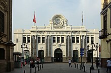
Lima also has an old railway station called the Homeless Train Station. It is located on the left bank of the Rimac River. His name is due to the Church of Our Lady of the Homeless who was next to the station. The project was started in 1890 by The Peruvian Corporation and three years later the Lima-La-Oroya route was inaugurated. The station building, on three levels, was the first public work planned by Peruvian architect Rafael Marquina and Bueno and was completed in 1912
Currently, it is exclusively used administratively, although it eventually offers cargo and passenger transport services from Lima to the central highlands. it also functions as an exhibition hall, among the main pieces of exhibition is the presidential coach called Paquita, which was ordered to build in honor of the wife of then Peruvian President Oscar Benavides.
Ground transportation
Due to its location in the center of the Peruvian coast, Lima is the confluence point of the main roads of the country. The capital communicates with all the coastal towns through the Panamericana Highway, which runs parallel to the sea; its northern section reaches Tumbes (border with Ecuador), 1370 km away and the southern section runs 1291 km to Tacna (border with Chile). The connection to the cities of the Sierra is through the Central Highway and some penetration routes affirmated to Yauyos, Huancayo, Huacho, Oyón, Huánuco, Canta, La Oroya, Pucallpa, among others. There are three trunking roads that come from Lima and that connect all over Peru:
- North American Highway, links the northern districts of the city (San Martín de Porres, Independence, Los Olivos, Comas, Puente Piedra, Santa Rosa, Ancón) with the northern departments (north of Lima, Áncash, La Libertad, Lambayeque, Piura y Tumbes). Several penetration routes are born from the road to the other departments of the north of the country.
- Central Highway, links the eastern districts of the city (Ate, Santa Anita, Chaclacayo and Lurigancho) to the central departments of the country (departments of Junín, Pasco, Huánuco, Ucayali). The central road has several branches of penetration in each of these departments.
- Pan American South Road, links the southern districts of the city (Santiago de Surco, San Borja, San Juan de Miraflores, Chorrillos, Villa El Salvador, Lurín, Punta Hermosa, Punta Negra, San Bartolo, Santa María del Mar and Pucusana) to the southern departments (south of Lima, Ica, Arequipa, Moquegua and Tacna) ... Several penetration routes originate from this road to the other departments of the south of the country.
The city also has a terraport called the Grand Terrestrial Terminal of Plaza Norte, opened in 2010, which allows buses to be boarded with national and international routes. there are also private terminals of some transport companies and there are other informal stations such as Fiori in the district of San Martín de Porres for routes to the north, Yerbateros in the district of Ate for Central and Atocongo routesin the district of San Juan de Miraflores for southern routes
Urban transport
One of the current major problems of the city of Lima is public transport. This situation has led to the construction by the municipal authorities of overpasses, bridges, road exchanges, expressways and slope steps as a formula to solve the constant congestion. this is why the development of public and private transport systems, such as the Metropolitan Transportation System, aimed at improving the safety and quality of transport service in Lima, has begun to take place, in addition to the construction of more than 1000. 0 km of bike lanes in Lima Metropolitana.
Metro
The Lima and Callao subway, popularly known as the electric train, is a metropolitan railway that currently has a single operating line, which runs through the city from south to northeast. The line operates almost entirely under the high-viaduct system, however it was determined that line 2 and the next four lines will be underground.
At the end of its first tranche in 1990, the system had a viaduct subway line of 9.2 km across three districts: Villa El Salvador, Villa María del Triunfo and San Juan de Miraflores. Although this initial stretch had thirty-two wagons and seven stations, the metro didn't get into operation, because it didn't have enough distance and demand to make it commercially profitable.
At the beginning of 2010, the project to construct the extension of Line 1 from the Atocongo Station in the district of San Juan de Miraflores to the Dos de Mayo National Hospital on Avenida Miguel Grau (in the center of Lima) began, adding a total of 21.48 km of route. With the conclusion of this new section, the Lima Metro was officially inaugurated on 11 1 July 2011. In November 2011, the construction of the final section of Line 1 began, which reaches a total of 35 km in length and was put into operation in July 2014. With some improvements made to the system after the opening of the second tranche, it currently transports about 500,000 people into one tranche working day.
Line 2 and a section of Line 4, belonging to Av. Elmer Faucett and Av. Néstor Gambetta, in the Constitutional Province of Callao, are also under construction.
Metropolitano

The Metropolitano is an integrated public transport system, with large articulated buses running through exclusive corridors, under the Rapid Transit Bus (BRT) scheme. Its construction started in 2006, during the mayoral management of Luis Castañeda Lossio and its commercial operation began on 28 July 2010 partially. The Segregated High Capacity Corridor (COSAC) covers a segregated route that runs from south to north across sixteen districts of the city from Chorrillos to North Lima.
The length of this trunk route is 26 km and the total number of stations is 38. It is complemented by food routes at its southern and northern ends. this service benefits more than 600 000 users per day. This system is similar to the TransMilenio in Bogotá or the Metropolitan Mobility Network in Santiago, Chile.
It is worth mentioning that its trunk route will expand north to the district of Carabayllo, it will be the last 10 km of the route and 18 new stations, thus completing the site and also the change or elimination of some backbones and feeders is planned.
Complementary corridors
Formed on the basis of the Integrated Transportation System, they make up a public transport system in the process of implementation, promoted by the municipality of Lima. It aims to reduce the number of current transport routes, renew the vehicle fleet, withdraw long-standing or low passenger capacity vehicles from circulation and integrate with other mass transport systems such as Metropolitano and Metro. On July 26, 2014, after questioning by the municipality of Callao and the transport unions, the first corridor called Corridor Azul, that runs along the Avenues of Tacna, Garcilaso de la Vega, and Arequipa entered into pre-operation.
Currently, there are 5 lines of the corridors, each identified with a color, which pass through some of the busiest roads in the city. They are distributed as follows:
Yellow Corridor: San Martín de Porres - Surco (With buses of 12 and 18 meters respectively)
Red Corridor: San Miguel - Ate / Lince - La Molina (with buses of 12 and 18 meters respectively)
Blue Corridor: Rimac - Barranco /Rimac - Miraflores /Rimac - San Isidro (with buses of 9 and 12 meters respectively)
Purple Corridor: San Juan de Lurigancho - Magdalena/San Isidro/Rimac (with 12-meter buses)
It should be noted that as much as the Metropolitano and the Complementary Corridors all of their fleet is made up of vehicular natural gas units to protect the environment and prevent the spread of smog.
Traditional Routes
Also known as "billed route system", "traditional bus system" , is the public transportation system that is prevalent not only in the city of Lima, but also in many other Peruvian cities. In the case of Lima, there are currently 511 urban transport routes, which are mainly provided by buses and microbuses.
Although it is currently in a global restructuring phase, the system has been being renovated with modern units following the last transport reforms since 2005. The rates vary between S/. 0.50 to S/. 4.00 depending on the distance of the journey.
Taxis
Because of the high unemployment margins that Peru faced in the 1980’s and the free import of used cars, there has been an oversupply of taxis and motorcycle taxis for several years. Although the Metropolitan Municipality of Lima started a reorganization of the Metropolitan Taxi Service (SETAME) several years ago, informal taxis still circulate, the vehicles do not have a meter, so the fare is negotiated when the service is taken.
However, there are numerous private radio taxi companies that provide door-to-door service and provide reliable and secure service. On the other hand, there are also taxi companies that can serve services between the international airport and the different hotels that the city has. These vehicles can also be rented for private tourist services, and they are much sought after by top executives visiting Lima.
The main difference between private-business taxis and conventional taxis is their external color, while private-sector taxis are mostly black, conventional ones vary between blue and yellow with red and white rectangles on doors and trunk. Many Lima taxis have started working for mobile application developers, through which exponentially increasing users use taxis to borrow.
Public Services
Education
Education in Lima, as well as in the rest of the country, is divided into different levels. Initial education, corresponding to the period between zero and five years of age, is in charge of the cribs that aim to provide children with the stimulations required for their integral development and the gardens that offer technical-pedagogical activities. Primary education begins with the first cycle, consisting of the first and second grade. The age of entry for children is six years. This level begins in the first grade and ends in the sixth grade of primary school.
Secondary education is five years, from the first to the fifth year. Then comes higher education that can be productive, technological, or university technician. In order to provide basic education (from initial to secondary), the city has 9,953 private educational centers and 5,083 public institutions. the Peruvian capital has the highest concentration of higher education institutions in the country. It houses more than fifty universities, among which is the National University of San Marcos, "Dean of America", the oldest in the Americas and the first in Peru, founded on May 12, 1551, giving rise to the celebration of Peruvian University Day.
Other public universities play an important role in teaching and research, such as the National University of Engineering, founded in 1876, the National University of Callao, the National Federico Villarreal University, the National Agrarian University La Molina, and the only national university dedicated to teacher training, the National University of Education Enrique Guzmán y Valle, known as "La Cantuta" located in Chosica and founded on 6 October July 1822 by the Liberator Don José de San Martín, giving rise to the celebration of the Teacher's Day, because it was the date of the founding of the first School of Recipients in Peru. The Pontifical Catholic University of Peru is the first private university in the country (founded in 1917).
Other university institutions located in the city are: César Vallejo University, University of San Martín de Porres, Inca Garcilaso de la Vega University, ESAN University, University of Piura, University of the Pacific, University of Lima, Peruvian University of Cayetano Heredia, Peruvian University of Applied Sciences, Private University of San Juan Bautista, Scientific University of the South, University of San Ignacio de Loyola, University of Ricardo Palma, Sedes Sapientiae Catholic University, among others. According to the results obtained in the Peruvian census of 2007, 93.44% of the people of Lima aged three or more are literate. In terms of the level of education achieved, 37.73% of the people have a secondary education, while 19.76% have completed higher education. Average years of study are 9 years
Health
According to the 2007 Census of Population and Housing, 41.86% of the population of Lima has some kind of health insurance, i.e. 3 285 178 people, yet 58.13% of the population does not have any insurance. the results obtained in the censuses also indicate that men and women have almost access to it. the same percentage as health insurance. Thus, 42.18 per cent of men, i.e. 1,566,399, and 41.56 per cent of women, equivalent to 1,517,572 persons, have some health insurance.
As for the type of insurance to which the population is affiliated, of the total number of persons who claimed to have some health insurance, 6.43 per cent are protected by the Comprehensive Health Insurance scheme, 24.55 per cent have access only to the social insurance EsSalud, while 12.22 per cent are affiliated with private insurance companies. with 367 establishments (188 health centers, 17 hospitals, six specialized institutes and 156 health posts) under the Ministry of Health of Peru; and with 48 care centers (fifteen hospitals, fifteen polyclinics, three medical centers, nine medical centers, five primary care centers and one clinic) belonging to the Social Health Insurance of Peru.
There are also a number of private clinics in the city, including: the Javier Prado clinic, the Good Hope clinic (promoted by the Adventist Church of the Seventh Day), the Maison de Santé clinic (founders of the French Charitable Society), the Stella Maris clinic (constituted by the Congregation of the Sacred Heart of Jesus Missionaries), the American Anglo, and the International and Ricardo Palma clinics ranked as 42 best clinics in Latin America by the magazine AméricaEconomics
Media
Written Press
The first daily newspaper in Lima was the Gaceta de Lima, which was first published in 1715. In 1790, the "Diario Curioso, Erudito, Econômico y Comercio" (Journal Curioso, Erudito, Economical and Commercial) was created, published by Jaime Bausate and Mesa; one year later, Mercurio Peruano, a biweekly newspaper published by a group of young intellectuals belonging to the society of lovers of the country, was founded. today the city is home to the main and largest newspapers of national circulation, among which: Depor, Diario Correo, Diario Oficial El Peruano, El Comercio, El Bocón, Expreso, La Razón, La República, Libero, Perú.21, La Nación, Todo Sport and Trome.
Radio
The first radio station in Peru, named OAX, was inaugurated on June 20, 1925 by then President Augusto Leguía. The first broadcast was led by the Peruvian Broadcasting Company and operated with teams from the British company Marconi. From Lima, they broadcast dozens of AM and FM stations with local, national and international reach. According to a survey conducted by the Peruvian Company of Market Studies and Public Opinion S. A. C. in 2017, Lima's most popular radio stations are: Radio Programs of Peru, Fashion, Karibeña, Romantic Rhythm, La Zona, Zero Wave, Panamericana, Nueva Q, La Kalle and Radio Felicidad.
Television
The history of television in Peru began in Lima in 1939, when the first experimental television demonstration was carried out in the country, when a film and an artistic program were broadcast from the National School of Our Lady of Guadalupe. Then another test was held, this time from Gran Hotel Bolívar on May 28, 1954. Finally on January 17, 1954 958, began its broadcasts on the state channel, with the transmission of a technical documentary.
Lima is home to the country's most important national television channels. The city has eight television channels (América Television, ATV, La Tele, Latina Televisión, América Next, Panamericana Televisión, Viva TV and TV Perú), which broadcast their programming by open signal for the whole country except for RBC Television which can only be seen in Lima and in some Peruvian cities via cable. The city also has numerous subscriber television and satellite TV providers, including: Best Cable, Cable Peru, Cable Vision Peru, Claro TV, DirectTV and Movistar TV.
Culture and society
Architecture
The architecture of the capital is characterized by a mixture of styles as reflected in the changes between the trends over several periods of the city's history. Examples of colonial architecture include structures such as the Basilica and Convent of San Francisco, the Cathedral of Lima and the Palace of Torre Tagle. These constructions were generally influenced by the styles of Spanish neo-classicism, Spanish Baroque and Spanish colonial styles.
In the buildings of the historic center, you can see more than 1600 balconies dating back to the colonial and republican era. The types of balconies that the city presents are the open, simple, drawer, corridos balconies, among others. After the Independence of Peru, a gradual shift towards the neoclassical and art nouveau styles took place. Many of these buildings were influenced by French architectural style.
Some government buildings, as well as major cultural institutions, were built during this architectural period. During the 1950s and 1960s, several buildings in a brutal style were built on behalf of the military government of Juan Velasco Alvarado. The examples of this architecture are the Museo de la Nación and the Ministry of Defense of Peru. the 20th century has seen the appearance of glass skyscrapers, particularly around the city's financial district. There are also several new architectural and real estate projects.
Parks and gardens
The largest parks in Lima are located on the outskirts of the city and are known as Parques Zonal. In the historic center you will find the Reserve Park, the Exposition Park, the Field of Mars, the University Park, La Muralla Park and the Castilla Marshal Park. The Reserve Park has the largest pool complex in the country, known as "The Magic Water Circuit."
Other important parks are located in various parts of the city, such as the El Olivar Forest, Reducto Park No. 2, the Pantanos de Villa, the Legends Park, the Miraflores Malecón, Friendship Park and Kennedy Park, to name a few. The route of the city's streets, is presented as a system of squares that have a purpose similar to roundabouts. Besides this practical purpose, the squares serve as one of the main green spaces of Lima and contain a wide variety of different types of architecture, ranging from monuments, statues and water fountains.
Dialect
The dialect of Lima is known as Peruvian riparian Spanish. It is characterized by the lack of strong intonations as in many other Spanish-speaking regions of the world. It is strongly influenced by the historical Spanish spoken in Castile. Throughout the colonial era, most of the Spanish nobility living in Lima was originally from this region. Spanish Lima is also characterized by the lack of voseo, a feature present in the dialects of some Latin American countries. The Limean dialect is distinguished by its relative clarity compared to other Latin American accents. The language has been influenced by a number of Italian, Andalusian, Chinese, and Japanese immigrant groups. It has also been influenced by anglicisms, as a result of globalization, as well as by Andean Spanish, due to the recent migration of inhabitants of the Andean Sierra to Lima.
Gastronomy
Limean cuisine has been the product of the fusion of the culinary tradition of old Peru with Spanish cuisine in its most strongly influenced variant by the Moorish presence on the Iberian peninsula and with important contributions from culinary customs brought from the Atlantic coast of sub-Saharan Africa by slaves. Later, this mix was influenced by the culinary customs and practices of French chefs who fled the revolution in their country to settle, in large numbers, in the capital of the Viceroyalty of Peru.
Equally momentous was the influence of nineteenth-century immigration, which included Cantonese, Japanese, and Italian Chinese, among other mainly European origins, as well as a strong internal flow from rural areas to cities, particularly to Lima in the second half of the 20th century. The city also has a wide variety of restaurants serving Creole, Chifa, cebicherías, and chicken food. Peruvian cuisine, widely represented in Lima, has several Guinness records for its diversity and quality. In 2006, during the annual Madrid event Fusion the city was declared the Gastronomic Capital of Latin America.
Religion
The arrival of the Spanish conquistadores in Peru meant the introduction of the Catholic religion in this area populated by Aboriginal people of various ethnicities, who followed animist and polytheist religions, which produced a religious syncretism. Through a long process of indoctrination and practices among the pre-Hispanic population, the Spanish friars made the faith their most important task. The city of Lima, the capital of the Viceroyalty of Peru, became in the 17th century a city of monastic life where saints such as Rosa de Lima (patron of Catholics in Lima, the Peruvian National Police, the Republic of Peru, the Americas and the Philippines) and Martín de Porres emerged.
The Peruvian capital is home to the Archdiocese of Lima, which was established in 1541 as a Diocese and in 1547 as an Archdiocese. It is one of the oldest Ecclesiastic Provinces in the Americas. The Archdiocese of Lima is currently in charge of Cardinal Juan Luis Cipriani. The city also has two mosques of the Muslim religion, three synagogues of the Jewish religion, a temple of The Church of Jesus Christ of Latter-day Saints located at La Molina, an Orthodox church located in the district of Pueblo Libre, five Buddhist temples. and six prayer rooms of the Ministerial God Church of Jesus Christ International.
According to the 11th National Census of Population and VI of Housing, 82.83% of Lima's population over twelve years of age declared Catholic, while 10.90% profess the evangelical religion, 3.15% belong to other religions and 3.13% do not specify any religious affiliation. one of the most prominent Catholic religious manifestations in the capital is the origin The Lord of Miracles, whose image that dates from the time of virreinal comes out in procession through the streets of the city in the month of October of each year. The Lord of the Miracles was named patron of the city by the Cabildo of Lima in 1715 and patrono of Peru in 2010.
Museums
The city is home to the largest number of museums in the country, with nearly fifty museums, including the National Museum of Archeology, Anthropology and History of Peru, which among its most important collections hosts an impressive exhibition of pre-Columbian textiles, the National Museum of Peruvian Culture and the Archeological Museum Rafael Larco Herrera, located within a virreinal mansion and presenting among its most outstanding attractions a fine collection of gold and silver from ancient Peru, the famous collection of erotic art and deposits where visitors can appreciate 45,000 properly classified archeological objects.
Both museums are located in the Pueblo Libre district and are connected by a pedestrian blue line that makes it easy for you to visit together. In Miraflores you can visit the Sala Museo Oro del Perú in Larcomar, which has a collection of pre-Columbian gold objects. Not only are there museums dedicated to exposing the manifestations of Peruvian pre-Colombian culture, but there are also museums of art, natural history, science, religion and theme. are the Lima Museum of Art, the Italian Museum of Art, the Museum of Natural History, the Museum of Electricity, and the Postal and Philatelic Museum of Peru. You can also visit some private collections open to the public such as the Museo Oro del Perú y Armas del Mundo (Gold Museum of Peru).
Sport
The main sport practiced in the capital is football, as in the rest of the country. In the mid-19th century, the first football teams in Peru began to emerge, resulting in the subsequent organization of football clubs or the inclusion of football in already formed clubs. The Peruvian Football League was officially created on February 27, 1912 and initially only had teams from the city of Lima that were reinforced by chalk footballers. Currently, five teams from the capital participate in the Peruvian First Division: Alianza Lima, Deportivo Municipal, Sporting Cristal, Universidad de San Martín de Porres and Universitario de Deportes.
Alianza Lima, Sporting Cristal and Universitario de Deportes are considered the most important teams in the country, for what they are known as the three biggest Peruvian football teams. Among these clubs are traditionally superclassical and modern classical, and together they are the most popular in the country. The main sports venue for this sport is the National Stadium of Peru, inaugurated in 1952 and with a maximum capacity of 55,000 spectators. Other important football stadiums are: Alejandro Villanueva Stadium, Monumental Stadium, Municipal Stadium of Chorrillos, Stadium of the National Mayor University of San Marcos and Alberto Gallardo Stadium.
Other sports less practiced in the city, but not least, are: athletics, badminton, cycling, horseback riding, five-a-side soccer, golf, karate, front palette, paragliding, rugby, squash, surfing, tennis, table tennis, shooting, triathlon, sailing and volleyball. For the practice of these other sports, the city has: the Coliseum Mariscal Cáceres (owned by the Peruvian Army), the Coliseum Eduardo Dibós, the Coliseum Amauta, the Field of Mars (owned by the Peruvian Institute of Sport), the Tennis Club Terrazas de Miraflores, the Inkas Golf Club, the Lawn Tenis Club of the Exhibition (home of the Peru Davis Cup team), the Lima Golf Club The Lima Cricket and Football Club and the National Sports Village Athletics Stadium. Also noteworthy is the fact that there are seven golf courses in the city itself, including the Monterrico Hippodrome in the Santiago de Surco district (owned by the Peruvian Jockey Club) and the Villa María del Triunfo Sports Complex.
The city has hosted several important events, in Lima five editions of the Copa América were disputed (1927, 1935, 1939, 1953, 1957 and 2004); in addition to the 1986 and 1995 South American Under-17 Championships, the 1975 South American Under-20 Championships, the 2003 South American Women's Championship and the 2005 U-17 World Cup.
In January 2009, the first date of the World Qualifying Series of Surf was held in Lima, and in November of the same year the sixth date of the ASP World Tour was held in the women's branch. In 2014, the ISA World Surfing Games were held. With regard to basketball, it hosted the 1964 Women's World Championships and the 1938 and 1943 South American Championships.
As for volleyball, the Peruvian capital hosted the 1982 Women's Volleyball World Championship, the South American Women's Volleyball Championship three times (1961, 1977 and 1997), the 1989 Women's U-20 World Volleyball Championship and 2011, the 2015 Women's U-18 Volleyball World Championship, the 2008 and 2012 South American Women's Volleyball Championship, the 2012 South American Women's U-20 Volleyball Championship, and the 2012 World Championship South American women's volleyball club team three times (2009, 2010 and 2013), in addition to other international tournaments such as the Federation Cup, the Four World Cup, the Latin Cup, the Pan American Under-23 Cup and the Pan American Under-20 Cup.
In the city of Lima, among the many public and private sports facilities, the most important ones are those that have set up sports venues (and, eventually, artistic ones) that can accommodate thousands of spectators. Of the national ones, the largest and most representative are the National Stadium of Peru (belonging to the Peruvian Institute of Sport) for 55,000 attendees, and the Stadium of the National Mayor University of San Marcos. Of the private or private, they highlight the Monumental Stadium (of the University Sports Club) for 80 thousand attendees, the Alejandro Villanueva Stadium (of the Club Alianza Lima) for 34 thousand attendees, the La Union Stadium (of the AELU) for 10 thousand attendees, the Monterrico Hippodrome (of the Jockey Club del Perú) for 8 thousand attendees, the Lolo Fernández Stadium from the University Sports Club) for 4,000 attendees, the Caballeros del Deporte (Country Club El Bosque) for 3,000 attendees, the Tenis Coliseum (from the Las Terrazas Club) for 2,500 attendees, the Soccer Stadium of the Club Regatas Lima for 2,000 attendees, and the Coliseum of Básquet and Voley of the Club Regatas Lima.
South American athletics, swimming, rugby and shooting championships have also been held several times in the city. In the last months of the year, the Challenger de Lima takes place. With regard to multidisciplinary competitions, it hosted the II Bolivarian Games in 1947, the IV South American Games in 1990, the I Bolivarian Beach Games in 2012 and the I South American Youth Games in 2013. In 2012, the last stage of the Rally ended in Dakar, and in Lima 2013 was the rally's starting point. In 2019 it also hosted the Pan American and Parapan American Games. .
| Predecessor: | Pan American City 2,019 | Successor: |
| Predecessor: | South American City 1,990 | Successor: |
Twinning Cities
Twinning cities is a concept whereby towns or cities from different geographical and political areas are paired together to foster human contact and cultural links. On October 12, 1982, the city of Lima joined the Union of Ibero-American Capital Cities by signing a declaration of multi-twinning and solidarity from all the capitals of Ibero-America. He is also a member of the Mercocities network. Lima is currently sister to:
Andorra la Vieja, Andorra.
 Asunción, Paraguay.
  Austin, United States
  Barcelona, Spain.
  Bogotá, Colombia.
  Brasilia, Brazil.
  Buenos Aires, Argentina
  Bordeaux, France.
  Caracas, Venezuela.
  Mexico City, Mexico.
 Panama City, Panama.
- Cleveland, United States
- Guadalajara, Mexico.
Guatemala, Guatemala,
Havana, Cuba.
 La Paz, Bolivia.
 Lisbon, Portugal
- Madrid, Spain.
Managua, Nicaragua
Manila, Philippines
- Medellin, Colombia.
- Miami, United States
 Montevideo, Uruguay.
  Beijing, China.
  Pescara, Italy.
 Port-au-Prince, Haiti.
- Rio de Janeiro, Brazil.
 Quito, Ecuador.
 San José, Costa Rica.
San Juan, Puerto Rico.
San Salvador, El Salvador.
 Santiago, Chile.
 Santo Domingo, Dominican Republic.
- São Paulo, Brazil.
Seoul, South Korea.
- Stamford, United States
- Sucre, Bolivia.
Tegucigalpa, Honduras.
- Toluca, Mexico.
See also
Portal:Lima. Content related to Lima.
- Cities in Peru
- Territorial organization of Peru
- Lima Metropolitana
- Urban Nomenclature of the Historical Center of Lima
- Metropolitan areas of Peru
- Global City
- Metropolitan areas of America
- Indicators of Latin American cities